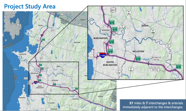
Imagine Interstate 89 in Chittenden County through 2050. How will people live and travel on the 37-mile corridor in a more safe, sustainable and efficient way over the next 28 years and beyond?
The Chittenden County Regional Planning Commission, the Vermont Agency of Transportation and other partners have been working for two years to answer that question. On Tuesday, they will present their findings and invite public comment.
The project aims to develop a comprehensive plan for the I-89 corridor that “identifies and prioritizes investments and multimodal strategies to provide for safe, efficient and reliable travel for all people, whether they are driving, taking the bus, or walking and biking through Interchanges,” said Eleni Churchill, transportation program manager for the planning commission.
It’s about planning for the future, said Dale Azaria, a senior fellow at the Conservation Law Foundation who’s on the advisory committee.
“The biggest challenge has been to get participants to think creatively about a better transportation system, not just more highway lanes and new exits,” she said in an email.
Wider highways with more exits “only encourage more driving, which will move us the wrong direction when it comes to greenhouse gas emissions, air pollution, noise, safety, and quality of life,” she said.
I-89 in Chittenden County is one of the busiest stretches of highway in Vermont and an area of continued growth. The Vermont Natural Resources Council sees the study as a way to design better travel routes and make improvements on Exits 12, 13 and 14 — and also as “a critical step” to strengthen climate resiliency in Chittenden County, said Kati Gallagher, sustainable communities program director of the council, which is part of the advisory committee.
In partnership with state, county and nonprofit partners, the study has assessed existing traffic and land use conditions along the corridor, created visions and goals, and identified five bundles of improvements — such as working on exits to improve bike/pedestrian safety and traffic flow — while being mindful of planned growth and funding improvements as a way to reduce future maintenance costs.
“We believe we developed a balanced plan that looks towards the future with climate change in mind, but also the mobility needs of the residents, commuters and visitors to our county,” Churchill said.
Highway studies have been conducted in the past but none quite like this one, said Joe Segale, policy, planning and research bureau director at the Vermont Agency of Transportation.
Segale conducted one such study himself back in 1998 when he worked at the planning commission.
“It wasn’t anywhere near as comprehensive as this one,” he said. “It’s taking into account other modes like walking and biking and transit and then it’s integrated with land use … so it’s a very robust study.”
In devising the plan, the commission sought input not just from transportation, business and environmental stakeholders, but also municipalities and residents through a public process. And it looked at socioeconomic data and how the plan might affect marginalized communities.
The biggest challenge? Forecasting future travel trends in a post-pandemic world, with so much uncertainty about where people will live and how demographics, land use decisions and new technology will affect how they travel, she said.
The goals include enhancing safety on the highway and at interchanges, improving access, supporting anticipated economic growth, preserving and improving the condition of I-89, minimizing environmental impacts and promoting compact growth that supports livable, affordable, healthy communities.
For Gallagher, the study has been an opportunity to avoid past mistakes. Experience has shown that expanding capacity for single-occupancy cars and widening roads has not been sustainable. Stakeholders now have an opportunity to reinforce Vermont’s land use goals and prevent sprawl, she said.
“The implementation of Vermont’s smart growth goals are more urgent than ever as we work to reduce our greenhouse gas emissions, 40% of which come from transportation,” she said.
The project, which kicked off in May 2019, is at the final stage, with a last public meeting scheduled for Tuesday at 6 p.m. It will be held remotely via Zoom.
Churchill said she hopes people will attend the remote presentation and provide input on the transportation plan. “Our interstate system is important, and we want everyone interested to have the opportunity to provide their feedback,” she said.
Response from the meeting will be included in a draft that will be presented to the I-89 advisory committee later this month, and the final report will come this summer. The plan will be monitored and reassessed periodically to ensure that it evolves with the times, planners note in the presentation.
Correction: An earlier version of this story referred incorrectly to the gender of Conservation Law Foundation senior fellow Dale Azaria.