


Particulate matter from wildfires in Oregon and southern Canada created hazy skies in Vermont on Monday evening and Tuesday, prompting state officials to issue an air quality alert for the entire state.
Across Vermont, air quality is considered “unhealthy for sensitive groups,” with values of up to 148 on the Air Quality Index on Tuesday afternoon.
“This is the lowest level that we see for air quality alerts to be triggered,” said Andrea LaRocca, a meteorologist with the National Weather Service in Burlington.
Air Quality Index values between 50 and 100 are considered moderate, while those between 100 and 150 are considered unhealthy for sensitive groups. Values above 150 are considered generally unhealthy. At around 3:30 p.m. on Wednesday, Bennington stood at 148, while both Rutland and Burlington had readings closer to 130.
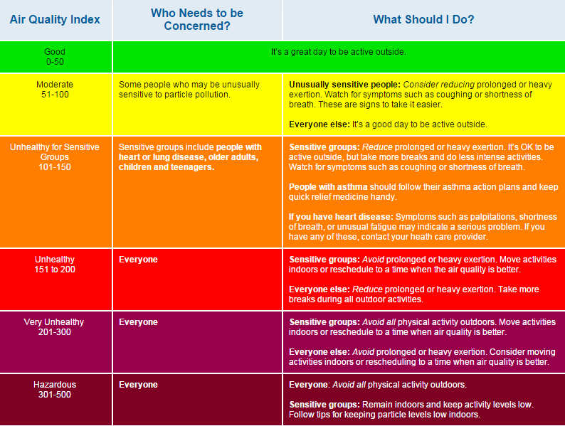
Anyone with a heart or lung disease should avoid prolonged or heavy exertion, and those with asthma are advised to keep medication handy, according to the Environmental Protection Agency. Anyone with heart disease should contact a health provider upon feeling palpitations, shortness of breath or “unusual fatigue.”
Roger Hill, a meteorologist based in Worcester, said a forthcoming cold front and thunderstorms will likely push the haze north. He said the worst of the conditions occurred Monday night through Tuesday afternoon.
“It’s very, very thick,” he said.
Oregon’s Bootleg Fire has burned through 364,000 acres, The New York Times reports. No deaths or injuries have been reported yet, though the fire has burned dozens of structures and has prompted thousands of evacuations. Additional smoke traveled to the Northeast from fires in the Manitoba area and other parts of southern Canada, where more evacuations are taking place.

Portions of Maine, Massachusetts, New Hampshire, New Jersey, New York and Pennsylvania are reporting air quality values similar to Vermont.
“It looks like it’s quite a bit of the country, really,” Hill said. “North of the Mason-Dixon line, approximately, everybody is seeing this.”
Smoke travels east when it’s caught in the midlevels of the atmosphere, above around 15,000 feet in elevation, he said. Then, it’s picked up by the low levels of the jet stream and pushed east.
“Of course, what ends up happening is a lot of this particulate matter sinks downward,” he said. “As it sinks downward, it’s causing bad air quality.”
While the cold front will clear the air in the coming days, Hill said he “wouldn’t be surprised to see another smoke layer back after that,” provided the wildfires are still burning.
Hazy skies caught Vermonters’ attention last September when another series of fires swept across the West. As climate change continues to prompt severe heat and drought conditions in the West, Vermonters are likely to see more of these conditions, Hill said.
“Folks, unfortunately, should get used to times of the summer that are going to be rather smoky and hazy,” he said, “and they’re going to look like what we’re seeing this afternoon.”

