Editor’s note: “Then Again” is Mark Bushnell’s column about Vermont history.
[I]ra Allen could almost smell the money. He had recently moved to the Hampshire Grants (what is today Vermont) from his home state of Connecticut and joined the family business, land speculation. Working with his older brothers, including the now legendary Ethan, Ira Allen aimed to buy up as much of this new territory as he could and sell it for a tidy profit.
In 1772, when he was only 21 years old, Allen saw his chance. He was asked to survey the boundaries of a town that had been granted, like much of the land in this new territory, by New Hampshire Gov. Benning Wentworth. The grant had been issued in 1763 to a group of 64 proprietors, none of whom ever intended actually to live on the land. They, like Allen, were only interested in it as an investment.
Allen, who had settled in southwestern Vermont, wasn’t familiar with the central part of the state, but this new town sounded promising. So Allen struck a hard bargain. He would gather a team to help him survey this remote area in exchange for a large portion of the town.
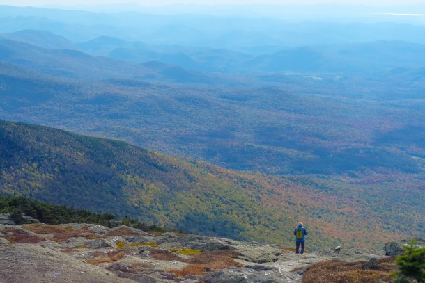
As he walked toward his new land, Allen might have dreamed of the riches that awaited him. But he might have seen his mistake even when he was still miles away. It stood out as plain as day. To follow the line marking the town’s northern boundary, Allen had to hike up and up. He was climbing what we now call Mount Mansfield.
A ‘worthless’ tract of land
When Wentworth divvied up the Hampshire Grants, he had done so from afar; he was near the New Hampshire seacoast. He had never set eyes on the land he was granting. Ira Allen realized as much while he lugged his weighty surveying equipment up the mountain.
The land, part of the Hampshire Grant, was named Mansfield after a town in Connecticut. It couldn’t have been more inhospitable. The ridgeline of Mount Mansfield, which runs north-south, neatly divided the town.
After surveying the town’s northern boundary, which crossed the area now known as Mt. Mansfield’s Adam’s apple, Allen might have walked up to the summit to view his portion of the town, which lay farther south. If he did, he was perhaps the first white man ever to do so. But the accomplishment wouldn’t have cheered him. What lay before him were steep inclines, rocky terrain and stunted trees.
As he worked, Allen’s mind must have raced, trying to figure out how he was going to squeeze anything good out of this experience. His cousin, Remember Baker, who was with him on the surveying expedition, teased him.
“I was the owner of very near one-third of the town, and could not discover lands that would (make) one good farm,” he later wrote. “This gave Baker an opportunity to pass many hard jokes on me respecting my purchase, &c.”
But Ira was not deterred. He was an Allen, after all, and they were nothing if not resourceful, and willing to bend the limits of honesty if necessary to serve their purposes.
In writing his report to Mansfield’s other proprietors, Allen neglected to mention the spruce-fir forest that covered the town. It would have been a tip-off that this was actually an alpine environment. Instead, he wrote of the land’s “gum-wood… tall Straight trees that had a gum, much like the gum on cherry trees, &c.”
He brought his map and report to a meeting with his fellow Mansfield landowners. At one point, he took one owner aside and quietly offered to buy out his holdings. The owner, “an ignorant fellow,” Allen later called him, did as Allen hoped, he told the others of Allen’s offer. The land, which only Allen had seen, must be worth a bundle, they figured. The others prodded Allen to sell and, after an appropriate delay, he yielded to their pressure.
“Having closed this business satisfactory to myself, I returned to my brothers’ and had a hearty laugh with my brothers Heman and Zimri, on informing them respecting the gum-wood, &c.,” he wrote.
Most of the land proved almost worthless. The only parts that could really be farmed were on the east side. The summit and the parts that are now covered with ski trails were useless, the 18th century being a more practical time than our own. Farmland is what counted. You couldn’t eat the view.
Still, people did move to Mansfield, albeit slowly. Those who came were either hardy or desperate, or both. One this is certain: the land was cheap. By the time the first settler arrived in 1799, the secret of Mansfield’s topography was out.
Zimri Luce, the town’s first official resident, reportedly paid $2 an acre for his land, which he settled with his wife and 10 children. Zimri’s brothers, Moses and Ivory, soon joined him in Mansfield.
It took until 1815 for Mansfield to have a large enough population to organize as a town. By 1820, the population stood at 60. It would peak at 279 in 1830.
Undoing Wentworth’s mistake
But the town remained bizarrely divided. Though most Mansfield residents lived to the east of the mountain’s summit, some did live on the west side. To visit neighbors on the opposite side of town, residents would have had to cross through either Smugglers Notch to the north of the summit or Nebraska Notch to the south. It was literally a divided community.
A town draped across a mountain just didn’t make sense, the Vermont Legislature decided. In 1848, lawmakers drew a line across Mount Mansfield’s summit, annexing the town’s lands to the west of the line to Underhill and those to the east to Stowe.
Change comes hard for some people, and that included early settler Ivory Luce. Perhaps he wanted to preserve his hometown, or maybe he just wanted to preserve his seat in the Legislature, which he was about to lose. Whatever his motivation, Luce succeeded in pushing through a law that seemed destined to reverse the annexation plan. The only way annexation would proceed was if residents of all three towns approved the plan.
Luce’s ploy failed, however. It turned out that the townspeople of Underhill, Stowe and Mansfield were all too happy to say good-bye to the town of Mansfield and undo Benning Wentworth’s mistake.