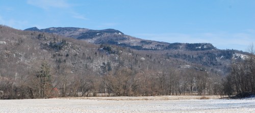
These mountains along the Winooski River in Jonesville have the traits of roche moutonnée, with gentle northwestern and steep southeastern slopes. Photo by Audrey Clark
Editor’s note: Landscape Confidential is a new column by Audrey Clark, a curatorial assistant at the Pringle Herbarium at the University of Vermont.
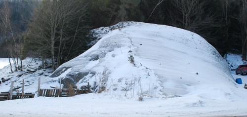
The barn-sized rock juts out of the earth just south of a house along Duxbury Road in Jonesville, within sight of the Winooski River. Its northwestern side is a smooth arch, while the southeastern slope is jagged, with crevices occupied by birch and pine trees. A dusting of snow has settled in hundreds of parallel grooves along the face of the rock.
Drive just a mile or two further south down Duxbury Road, and you’ll get a clear view of mountains across the river in three arching stair steps. Along the way you’ll pass, within sight of the road, several bedrock outcrops also corrugated with parallel grooves.
The giant rock and the mountains are classic examples of what geologists call roche moutonnée (pronounced rowsh mootawnay). It’s a French term that means, literally, “sheeped rock.” It describes rocks that have been abraded and gouged by glaciers into a characteristic shape, with a gradual upslope and an abrupt downslope.
Roche moutonnées are found all over Vermont, from the northern Green Mountains (think Camel’s Hump) to the southern (Bird’s Eye Mountain in Castleton). Many of them are easy to see from the interstate, like the view from French Hill in Williston heading south on Interstate 89.
John Van Hoesen, a geology professor at Green Mountain College, says that the term “roche moutonnée” was coined to describe dozens of rock outcrops, no more than 100 feet tall, scattered across alpine landscapes in Europe. These outcrops looked, to the geologist who described them, like sheep lying in a field.
Some sources beg to differ on the origin of the term, however. A classic glacial geology text, “Glaciers and Glaciation” (by Douglas Benn and David Evans, Routledge, 2010), says the 18th-century geologist who coined the term thought the rocks looked like a popular wig style of his time, which was held in place with mutton fat — hence “moutonnée.”
Whether sheep or hair, these roches were certainly shorn.
The most recent North American ice age produced an ice sheet that, 15,000 years ago, extended all the way to Long Island. This Laurentide ice sheet centered in northern Quebec, where it was two miles thick. The center of the ice sheet is called the zone of accumulation, where snow added on top of the sheet year after year is compressed under its own weight and turned to ice. Ice flows from the thicker portions of a sheet to the thinner, so from northern Quebec the ice oozed outward, radiating into Vermont. Here, it oozed roughly northwest to southeast and was about a mile thick — covering even our tallest mountains.
The sand, gravel, cobbles and boulders an ice sheet picks up as it inches over the land act like very coarse-grained sandpaper, scouring clean the valleys, scoring the bedrock, and scraping the mountains bare. The gouges created by these hitchhiking rocks are called glacial striations. Striations run parallel to each other in the direction of the ice flow, so that today you can tell which way the ice sheet was headed.
This massive sheet of frigid sandpaper, pressed hard against the land’s surface, grinds slowly up the northwestern slope of a mountain, polishing it. The pressure is already tremendous under a mile of ice and it increases as the ice grinds upslope. This pressure melts the ice in contact with the earth. Then the sheet bends, cresting over the mountaintop. It doesn’t conform perfectly to the shape of the mountain, though — there are little gaps between the ice and the downward slope. Ice water floods into this gap like pressurized soda shooting from a can, as Van Hoesen put it, and power-washes the mountainside.
Released from the pressure, the water freezes again. Because the water has been fire-hosed into cracks in the bedrock, when it freezes and expands it pries chunks off the mountainside. These boulders get carried along with the ice sheet, bound southward to grind other mountains smooth.
The result is a mountain shaped like Camel’s Hump: gentle on the northwestern slope, snaggle-toothed and steep on the southeastern.
According to “Glaciers and Glaciation,” a study in New England found that more than 100 feet of rock had been removed, on average, from the steep sides of large roche moutonnées, while just 13 feet had been scraped off the gentle slopes. So while a mountain like Camel’s Hump was certainly not created by glaciers, it was dramatically shaped by them.
Geologists aren’t completely sure Camel’s Hump is a roche moutonnée, though. Stephen Wright, geology professor at the University of Vermont, said it looks like a roche moutonnée, but he’d like to see striations up there to confirm it, and he hasn’t. Granted, he hasn’t looked hard for them. But he points out that because it’s an exposed mountaintop, Camel’s Hump is so highly weathered that any striations it might have had are now harder to find. (None of the five geologists contacted for this article were willing to confirm that Camel’s Hump is a roche moutonnée).
Even if you can’t confirm that a mountain or outcrop is actually a roche moutonnée without hiking up there to check for striations, once you become familiar with the shape, you’ll see them all over Vermont. They are part of the icy footprint left by a massive, slow-moving beast. By 10,000 years ago, the footprint was all that remained of the ice sheet in Vermont.