
Updated at 8:24 p.m.
Mountain towns across southern Vermont were pummeled with more than 8 inches of rain late Sunday and Monday, according to the National Weather Service, as rivers around the state continued to rise.
The flooding prompted more than 50 swift water rescues conducted by 11 teams, according to Vermont Emergency Management spokesperson Mark Bosma — mostly in Londonderry, Ludlow, Weston, Bridgewater, Andover and Middlesex.
“It’s not letting up,” he said. “They’re still responding to calls.”
Precipitation totals released by the weather service’s Burlington office just before 7:30 p.m. Monday showed that 9.05 inches of rain had fallen in Plymouth over the previous 24 hours. Elsewhere in Windsor County, 8.65 inches fell in Andover, 7.54 in Weston and 7.1 in Bridgewater Center.

In Rutland County, according to the weather service, Mt. Holly was hit with 8.66 inches and Belmont with 6.86. Washington County saw 7.11 inches in Berlin, 6.87 in Waitsfield and 6.81 in Worcester. In Lamoille County, Morrisville recorded 7.02 inches and, in Orange County, Vershire had 6.83 inches.
Follow all of our live coverage:
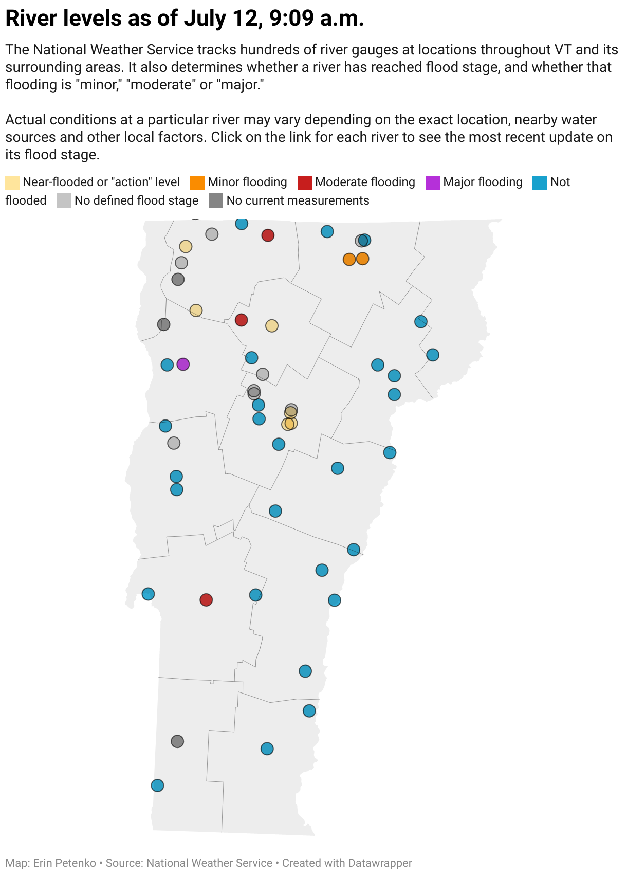
- Rivers swelled, roads were damaged and dozens of people were rescued by boat
- Calling flood damage to property and infrastructure ‘unavoidable,’ state officials focus on saving lives
- Several Vermont rivers hit flood stage, National Weather Service reports
- Providers concerned for Vermonters living outside
- Residents urged to use caution around propane and fuel tanks
- Amtrak cancels train to Burlington
- I-89 closed from Berlin to Middlesex
- Barre: Shelter prepares to evacuate
- Barre: Auditorium stands ready to shelter residents, but many remain stranded
- Berlin: 2 manufactured-home communities advised to evacuate
- Burlington: Volunteers turn up in droves at Intervale Center in a last-hour effort to save crops
- Hartford Village: Bridge construction wiped out as ‘Mother Nature changed it’
- Ludlow: State’s highest rainfall total turns Okemo Mountain hub into an island
- Montpelier: As city braces for major flooding, residents urged to evacuate low-lying areas
- Montpelier: Capital floods to first floor of its downtown streets
- Proctorsville: Watching waters rise evokes memories of Irene
- Richmond: Restaurant owner fears for his business
- Stockbridge: Residents see echoes of Irene in Monday’s flooding
- Waitsfield: The Mad River swells in Waitsfield
- Waterbury: Officials evacuate Vermont’s emergency operations center
- Waterbury: Residents on Randall Street pack up their belongings
- White River Junction: ‘A whole forest is floating down’ the river
- Weston: Flooding wreaks havoc
- Winooski: Debris cleared from dam; officials expect river to approach Irene levels
- PHOTOS: As rain pelts the state, Vermonters respond
- VIDEO: Scenes from the rain and flooding in Vermont
- SHARE: How have you been affected by Vermont’s rainfall and flooding?
“This is definitely the most significant flooding event we’ve seen since Irene,” said National Weather Service meteorologist Matthew Clay, referring to the 2011 tropical storm. In some parts of southern Vermont, he said, rain totals have already exceeded those seen during Irene.
“The communities down there, from what we’re hearing, have experienced complete devastation,” Clay said.
As rainfall begins to taper in southern Vermont, according to Clay, it’s expected to shift north into central Vermont. That could exacerbate the next threat facing the state: the flooding of major waterways, such as the Winooski, Lamoille and Mad rivers, along with the Otter Creek.
Clay said the Winooski River was likely to crest late Monday night or early Tuesday, posing a particular threat to Montpelier, Moretown and Essex Junction.
“Anyone near the river has to be on high alert because we’re expecting the Winooski to rise overnight,” he said. “Just because the rain ends doesn’t mean the flooding is over.”

According to Bosma, state officials are most concerned Monday night about floodwaters reaching homes while occupants are asleep.
“We want people to be hypervigilant tonight. Follow the forecast. Check river levels. Take a peek outside every now and then,” he said. “Evacuate early. If it looks like water is approaching, you don’t want your evacuation route to get swamped before you’re able to get out.”

Clay said the weather service expected rain to dissipate on Tuesday and to begin drying out Wednesday — but he cautioned that Thursday afternoon and evening could bring another round of thunderstorms. Even another half-inch of rain in certain waterlogged areas could cause additional flash flooding, he warned.