
St. Albans could redraw its City Council wards for the first time in more than 50 years.
That’s if councilors approve a map proposed by state Rep. Mike McCarthy, D-St. Albans City, who also is the city’s Ward 4 alderperson. The map would eliminate major differences in the populations of each ward, McCarthy said, and is designed to line up with single-member districts that have been proposed by the Vermont House of Representatives.
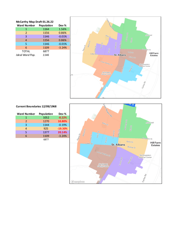
St. Albans is divided into six wards, with each represented by one alderperson. The current boundaries were adopted in 1968 and, under the city’s charter, they can be changed “from time to time,” though not more than once every five years.
“We took that really seriously,” McCarthy joked at last month’s City Council meeting. “A lot has changed in the City of St. Albans since 1968.”
Though the city’s population has decreased since then, according to the U.S. Census — from about 8,000 residents in 1970 to about 6,880 residents in 2020 — the density of some neighborhoods has changed. The ideal population for each ward today is 1,146 residents, McCarthy said, but some have deviated significantly from that figure.
For instance, Ward 5, in the city’s southeast corner, has 1,377 residents. But Ward 4, which is directly north, has just 955. Those wards both deviate about 20% from the ideal figure, McCarthy said, which seems to violate the U.S. Supreme Court standard of “one person, one vote.”
Ward 1, the city’s northeast corner, deviates about 8% from the ideal figure with 1,052 residents. Ward 2, which is largely in the city’s northwest corner, deviates more than 10%, with 1,270 residents. Wards 3 and 6 are close to ideal as they currently are.
McCarthy’s proposal would make large changes to several of the wards, and reduce the deviation from the ideal population across the board to no more than roughly 3%.
Ward 4 would extend south into an area that is currently part of Ward 5, while Ward 2 would swap part of downtown for more area south of Lake Street. Ward 3 would include more of downtown, with a piece extending north up to Lower Newton Road. Ward 1 would be extended west between Lower Newton Road and the city’s northern border.
At February’s meeting, councilors expressed broad support for the proposal.
Ward 5 Alderperson Bob Farrar said he had spoken to several constituents about the changes, and all of them agreed it was a good idea.
“Something has to be done,” Farrar said. “And this is as good as it can be done.”
McCarthy said the new map also would make sure no wards are divided between two House districts, should the Legislature approve a redistricting map that would split St. Albans’ existing multimember House district into two single-member districts.
Currently, McCarthy jointly represents a district that includes the city and a portion of St. Albans Town along with Republican Rep. Casey Toof. The rest of St. Albans Town is in its own House district and represented by Republican Rep. Lynn Dickinson.
Under a new district map that’s been negotiated by the House Government Operations Committee, of which McCarthy is a member, the northernmost of two new districts would include about two-thirds of the city. The southernmost district would include the rest of the city as well as the southern portion of St. Albans Town.
With McCarthy’s city council map in effect, Wards 1, 2, 3 and 4 would be included in the all-city district, while Wards 5 and 6 would be part of the district that includes the town.
McCarthy said the proposed single-member districts could only match the boundaries of the city’s wards if the council reduces its imbalances in the population. That’s why the two proposals go hand in hand, he said.
“I think it makes it easy for voters to understand: They live in this ward; this is who their representative is,” McCarthy said.
Should McCarthy and Toof run for reelection this fall and win, McCarthy said, he likely would represent the all-city district, and Toof would represent the other.
McCarthy said the city council could approve the new maps as soon as its March 14 meeting.