This story by Tommy Gardner was published in the Waterbury Record on June 27.
[I]t can take a while before you can describe a landslide in the past tense, and the slide that has taken out more than a dozen acres of a hillside abutting Cotton Brook in Waterbury is still very much present.
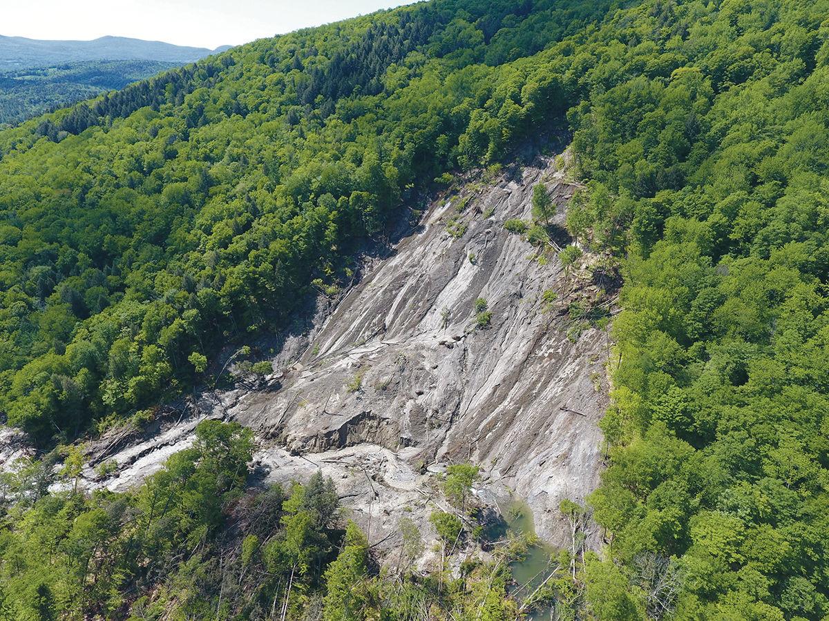
According to Vermont state geologist Marjorie Gale, the slide has taken out 250,000 cubic meters of material from the hillside, and may be Vermont’s largest landslide in modern times.
For geologists, it’s difficult to make a map when your boundaries keep changing every day.
“We see changes every time we go out there,” Gale said.
She and other state workers have been monitoring the slide from the air and on the ground since it started May 31, making four trips to the site, including one Monday.
Gale and others recommend people stay away from the slide, because pieces of the hill are constantly breaking off.
“It’s still active and still dangerous,” she said. “We have a crust over it all, but if you were on it and it started to move, you wouldn’t be able to get out.”

Scene of the slide
Hiking nearly 2 miles to the landslide last Friday, you might not have known something was amiss. Foster’s Trail is drained quite well. There are a few muddy spots, but that’s normal after a gully washer like the day before.
The actual Cotton Brook tells a different story.
Its waters are opaque, the whitish tinges that usually give the waterway its name supplanted by brown, a lighter-colored version of the chocolate river from Willy Wonka’s Chocolate Factory. In places where smaller hillside streams feed into the river, the water coming in is crystal clear, a neat counterpoint to the murk.

The slide’s top and bottom are bookended by popular hiking and biking byways, Cotton Brook Road at the bottom and Foster’s Trail near the top.
Cotton Brook Road open to non-motorized vehicles in the summer — it’s part of a much-used snowmobile network in the winter — is likely to reopen soon.
Or, at least soon after the earth stops sliding, said Michael Snyder, commissioner of the Department of Forests, Parks and Recreation; he lives in Stowe and is familiar with the popular recreational area.
Snyder said his department will try, eventually, to “create an alternative” to Foster’s. But for now?
“Foster’s Trail is just not coming back,” Snyder said. “It’s gone.
Indeed, on Friday, a blue sky opening above a clearing ahead is the first sign that there’s a big cleft in the forest. The trail ends abruptly, cut off in mid-ascent, like an unfinished interrogative.
Different shades of brown illustrate that this thing isn’t done moving. The silty, clay-beige landing zone turns to striations of gravel and sand, leading to dark, fresh topsoil at the edges, soil still moist from the previous day’s rain, and from its recent wresting from the newly formed embankment.
On the slide’s western edge, tall and slender adult trees stand, for now, half of their roots in suspension several feet off the slope. The only thing keeping them in, for now, is the other half of their root radius.
Gale said the actual slide area is now calculated at 12 acres. But walk around the whole thing, and you’d see numerous ground cracks all around.
“We have another 2.2 acres that is ready to fall in,” she said.
Gale said the unique soil composition in the Cotton Brook area — it’s a 14,000-year vestige of Glacial Lake Winooski — made for a unique slide. Rather than being undercut by the river, as slides often start, this one started right from the slope.
Gale said a layer of clay lay under the topsoil and sand and gravel, and that layer was sloped at 28 degrees. So, as surface water gradually infiltrated through the silt and sand, it couldn’t penetrate the clay, and the whole upper crust simply slid off in one huge chunk.
Gale believes the initial slide happened so abruptly, trees were still standing erect, still rooted to the topsoil, as they “rode down like on a magic carpet.”
At the bottom of the slide, the trees strewn like a dropped box of toothpicks still have leaves on them, live wood swept away in the rest of the flotsam.
All the fresh timber smells like a lumberyard.
It’s unclear how things will turn out, as the brook finds new ways through the mess, and a new geological feature has emerged in the wake of the landslide.
Danger downstream
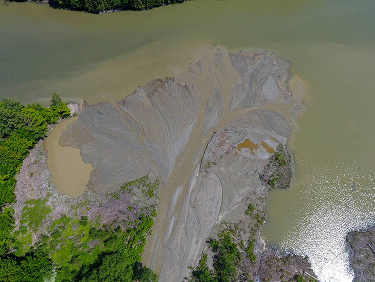
Gale said the sediment carried away by the slide has created a 2.8-acre delta at the mouth of Cotton Brook where it dumps into the Waterbury Reservoir. The sticky mess is now a dangerous swath of quicksand, and Gale and Snyder said boaters and paddlers using the Cotton Brook boat launch to reach the reservoir should exercise caution.
More impending disaster lies upstream of the slide. Gale said the river is so choked off that it has created a new 1.8-acre pond. If that gives way, she said, it will send a sudden deluge downstream.
“So, if anyone in the brook anywhere between the slide and the reservoir hears cracking trees, or sees a change in the turbidity in the water, get to high ground,” she said.
Rachel Fussell, executive director of the Stowe Trails Partnership, said she and her husband and the dog were biking up Foster’s the day the slide started, not that they knew that.
“My husband was ahead of me, and he turned around and came back, ghost-white,” Fussell said. She thought maybe he’d seen a bear cub and an angry mama. “He was like, ‘turn around, we’ve gotta go. Move quickly.’”
The Fussells may have been among the first people to come upon the slide on May 31. An hour earlier, and they could easily have been on the trail when the hillside gave way.
The Cotton Brook area is a great place for beginning to intermediate mountain bikers, thanks to its gently sustained hills and well-drained, smooth surfaces. Many people who prefer to get between Stowe and Waterbury using pedal power — but not comfortable braving a Route 100 shoulder — use the area as a connector.
Dog walkers take their pooches out there, and trail runners hit it hard for training.
But for now, Fussell, Snyder and Gale and anyone else in a position of authority in outdoors recreation is not comfortable telling people it’s OK to use the area yet. Fussell is waiting for a report from the geologists, and the geologists are still trying to literally unearth data on the slide.
“It’s kind of an unknown right now, and I don’t feel comfortable telling people we can go out there,” Fussell said.
Added Snyder, “Just lay out for a while. We’ve got lots of places in this state to explore.”