The group — including lawyers for Hannaford and opponents of the development — followed the canal to a spot where it had been diverted from Patrick Brook. The main branch of the brook flows along the north side of the commercial park, under Rt. 116 and drains into the LaPlatte River and from there into Shelburne Bay — the source of drinking water for much of Chittenden County.
The site visit was the prelude to a three-day trial in Environmental Court that concluded last week. It was the latest round in a five-year struggle between the supermarket and its opponents.
The court is expected to decide by February whether Hannaford can move ahead with construction.
The standoff is not about Hannaford, it’s about where the structure would be sited: on top of a small wetlands. Local residents are fighting the development, while the state says the wetland isn’t significant enough to warrant protection.
In November 2010, Hannaford submitted an application to build a 36,000-square-foot supermarket and pharmacy on Lot #15 in Commerce Park, located near the community’s core. In 2014, Hinesburg’s Development Review Board approved the application – with many conditions — by a single vote. The Hannaford grocery, which would be connected by sidewalks to the town’s center, conforms with the Hinesburg Town Plan.
Both Hannaford and Responsible Growth Hinesburg, a group that was formed to challenge the grocery store development, appealed the decision to Vermont’s Environmental Court.
Responsible Growth Hinesburg has a core group of about a dozen volunteers who have raised $168,000 through grants, fundraisers and donations to pay for consultants and an attorney, James Dumont, who practices in Bristol. Hannaford, the Portland, Maine-based supermarket chain, is represented by Downs Rachlin Martin, a large statewide law firm.
Hinesburg, a community near Burlington with about 5,000 residents, has one small grocery store in town — 93-year-old Lantman’s Market.
The Hannaford project has supporters, as well as critics. Resident Barbara Hicken does her weekly shopping outside of Hinesburg – “using up gas,” she said – because the prices are lower and the selection wider. “Bringing a ‘big’ store to Hinesburg is not the end of our town,” she noted. “It is called progress.”
According to a 2013 impact study by Richard Heaps, the new supermarket would create jobs and bring money into Hinesburg – 94 jobs, 63 part-time and 31 full-time. Heaps estimated the annual payroll would have been $2 million if the business had been up and running in 2013. Heaps said the Hannaford Supermarket would have “a small, positive impact on municipal property tax bills.” Lantman’s in 2013 employed 76 people, including 55 full-time and 21 part-time jobs. Its payroll for the year was estimated at $1,650,000.
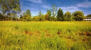
Whether Hannaford would be a good neighbor is not at issue. But there is substantial disagreement about whether the company should fill in 1.63 acres of wetlands on Lot #15.
To understand the arguments, it helps to visualize the 4.6-acre lot. It is shaped roughly like a slice of pie pointing northeast, with a large bite taken out of its tip.
Originally, Lot #15 was classified as a Class II wetland. That designation means a wetlands provides – to a “significant” degree – at least one of 10 functions, such as water storage for flood water or groundwater protection. Filling in a Class II wetlands is not permitted.
In 2013, Laura Lapierre, the Agency of Natural Resource’s Wetlands Program Manager, changed the designation to Class III. In testimony she said although the wetlands provides storage for flood water and stormwater runoff and protection for surface and groundwater, it is not at “significant” levels.
“The wetland is degraded and relatively isolated,” she said. “Because of the dense clay soils, the wetland is not considered a groundwater recharge wetland for the source protection area. Clay soils provide a restrictive layer that prevents water from traveling down.”
In 2014, the Army Corps of Engineers issued a permit to fill the wetlands with 37,000 cubic yards of gravel.
At this month’s court hearing, Hannaford’s civil engineer presented the design of a plan to replace the wetland’s function by intercepting runoff in two collection tanks and allowing contaminants to settle. An inadequate culvert on Commerce Street would be replaced to correct current flooding.
Andres Torizzo, of Watershed Consulting Associates, challenged the design, because a computerized stormwater modeling report for a 100-year storm showed a “storage range exceeded” warning. Adding data about the effect of an undersized culvert under Route 116 on Patrick Brook showed the water nearly overtopping Rt. 116, he said.
Hydrogeologist Stephen Revell questioned the state’s reclassification of the wetland, citing soil boring data by a Boston company that revealed a 5-foot deep layer of sand in the southern corner of Lot #15. Sand provides “outstanding water quality treatment” by hosting organisms that digest organic matter and act as a binding agent for phosphorus. The sand, he said acts like “a sponge which is capable of storing, filtering and treating waters which pass through them on their way to Patrick Brook.”
Torizzo disputed the Agency of Natural Resources’ characterization of the Lot #15 wetland as “isolated,” since Revell’s analysis showed that water seeps into the wetland from the canal and from uplands.
Torizzo also challenged Lapierre’s claim that Lot #15 wetland “receives no manure or septic leakage.” Runoff conveyed through the Patrick Canal at times is almost certainly contaminated with e.coli from human and animal feces from malfunctioning septic systems and agricultural sources, he said.
Revell said that by itself the preservation of the Lot #15 wetland will not restore the LaPlatte River, “but the same could be said of every wetland in the LaPlatte River watershed.”