

In the 1930s and ’40s National Life Insurance Co., in Montpelier, commissioned engravings celebrating milestones and achievements in Vermont history that ran as advertisements in the “Saturday Evening Post.” One of the engravings imagines James Wilson working in the shop behind his house in Bradford to make a world-class globe. Photo courtesy of National Life Group
Editor’s note: This article is by Nancy Price Graff, a Montpelier freelance writer and editor. In This State is a syndicated weekly column about Vermont’s innovators, people, ideas and places.
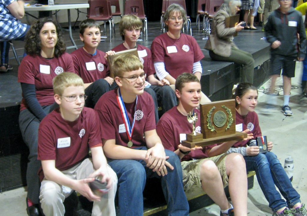
Harry Schukei and Ryan Parker, eighth-graders from BFA-Fairfax, recently aced their parts in the Vermont Principals’ Association 2014 Geography State Championship in Northfield. Of the 72 points they could have earned for their school team, they won 68. Every time the judge asked them a question, they hopped from their seats like startled rabbits.
What is the new name for a landmass in Australia once called Ayers Rock? What country did Bangladesh separate from in 1971? By the end of the contest, BFA-Fairfax had bested A.D. Lawton School in Essex, Castleton Village School, and Georgia Middle School.
The 24 fifth- through eighth-graders who competed in the championship are growing up in a world that constantly remakes itself. Three years ago South Sudan was not a country; now it is. A month ago Crimea was part of Ukraine. Now it’s part of Russia. What happened to several small islands off the coast of Australia? They used to be there; now they’re not.
Schukei occasionally studied the palms of his hands while he waited his turn, as if he had maps tattooed there. But maps — the stock and trade of geographers for thousands of years — would not have helped him much in this contest. These students answered questions about geological events, world currency, demographics, national boundaries, climate, state nicknames, the numbering system of interstates, environmental issues, where certain species of animals live, and a dozen other topics.
When he wants to study or rehearse for a competition, Schukei goes online, he says. He began his geography studies as a child watching National Geographic documentaries; now he just plugs in his computer.
Studying geography wasn’t always that easy.
Geography is an ancient science. The first maps were probably drawn by the earliest humans. When Christopher Columbus set sail from Portugal in 1492 to prove that the world was round — a myth every schoolchild hears — he was on a fool’s errand. Most educated Europeans already knew the earth was a sphere, and a German made the first known globe that very year. Between 600 B.C. and 1800, most of the advances in geographical knowledge came from men who were willing to risk their lives to explore the world firsthand and map it, cove by isthmus, mountain by plain.
“As long as it concerns space or place, it’s geography. Geography is the why of where,” says Reese Hersey, quoting another geographer. Hersey is a lecturer in geography and environmental science at the University of Vermont. Bespectacled and soft spoken, he considers himself a literary geographer, that is, someone who is interested in stories about place.
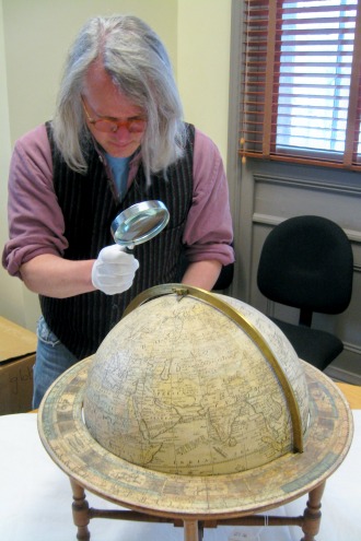
Recently Hersey visited the Vermont Historical Society, in Barre, to study a globe in its collection. Made in 1811, it is one of the oldest globes made in the United States, and every part of it — from its engravings to the paper to the inks to the wood-turned stand — was made by James Wilson, maker of the first globes in America.
Hersey donned white cotton gloves to keep oils from his hands from contaminating the fragile object, picked up a magnifying glass, the better to read the finely engraved words, and began slowly spinning the 13-inch sphere. He found stories everywhere.
“This is interesting. He’s done a pretty good job of laying out the land forms,” Hersey said after his first look at the globe.
According to Hersey, “the coasts mattered the most.” He pointed out that globes were most useful to mariners and that eastern coastlines tended to be more thoroughly mapped than western coastlines. To make his point, he ran his gloved fingers down the east coast of the United States, which is crammed with the elegantly engraved names of ports. Then, he pointed to the west coast, which offers up only a half dozen Spanish names.
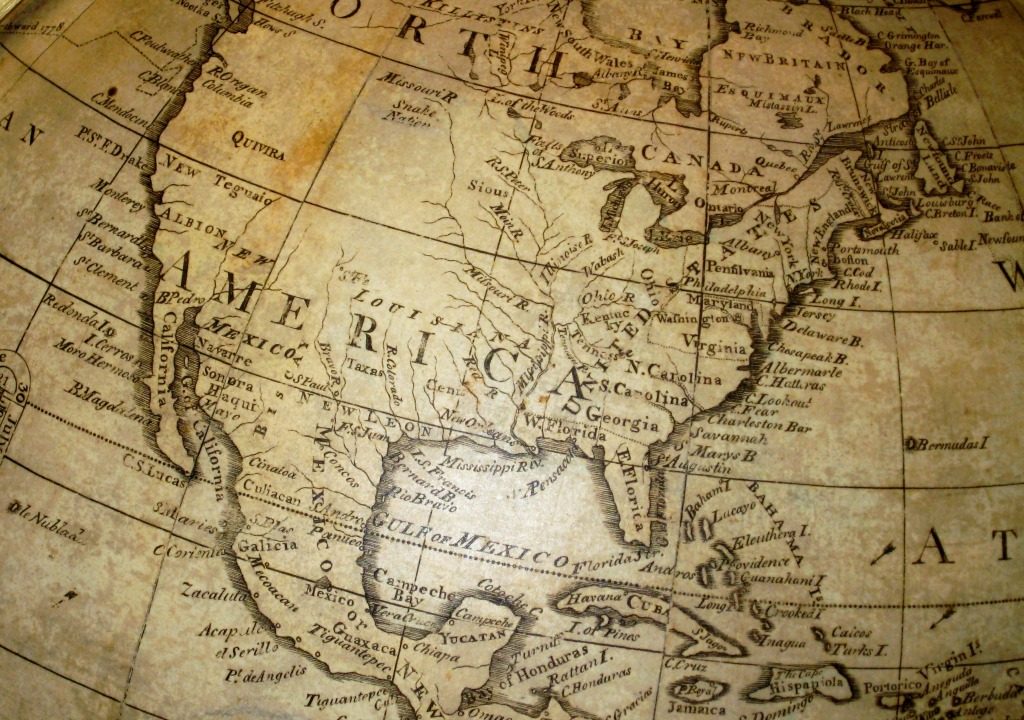
Continental interiors were mapped later, and early cartographers tended to be Eurocentric, so their projections of land forms tended to emphasize Europe and North America over South America and Africa. The innovation of using a sphere solved the biggest challenge of laying out landforms on gridded flat maps.
Hersey notes that the southern United States, which is depicted just after the Louisiana Purchase of 1803, virtually doubled the size of the country, and that the Mississippi River is finely drawn, but most of the vast new inland territory still awaited exploration and detail. States in the new territory don’t exist yet, but Native American tribal lands are labeled – “Sious” and Snake, for example. Across the ocean, the Horn of Africa is labeled “Negroland.”
“Poorly mapped regions were named after the mapmaker’s imaginings of who lived there,” said Hersey. He explains that the monikers were not intended to be offensive but descriptive, a way for cartographers to brand a little-known area with the race or ethnicity of the people who occupied it.

Who was James Wilson, and what is the history of his globe?
Wilson was born in Londonderry, N.H., but moved as a young, uneducated man to Bradford, Vt., in 1796, where he bought farmland on which to settle. At some point he stopped at Dartmouth College and saw his first globe. In the late 1700s in the United States, all globes were European made. To Wilson, the globe at Dartmouth was a revelatory way of seeing the world. He determined to make one himself that would be the equal of any made in Europe.
Wilson needed 14 years to acquire all the skills necessary to make a world-class globe. He taught himself papermaking, woodturning, blacksmithing, ink-making, and engraving.
He bought an 18-volume set of the Encyclopedia Britannica to teach himself geography, cartography, astronomy and geology, and then he made a magnificent desk, now at the Bennington Museum, in which each volume has its own wooden slipcase.
When he needed help with engraving, he walked 500 miles roundtrip to Yale to have master engraver Amos Doolittle give him lessons. When he needed help mastering the use of meridians to give the globe proportion and scale, he walked to Charlestown, Mass., for help from Jedidiah Morse.
Wilson’s first globe sold for $50, a small fortune.
And then he and his sons made many more globes, both terrestrial and celestial, in three different sizes. These matched or exceeded in quality the European models. The manufactory eventually moved to Albany, N.Y., but Wilson stayed in Bradford while his globes went out across the country.
Today a number of them, both terrestrial and celestial, can be found in Vermont, at UVM, the Vermont Historical Society, the Bennington Museum, Norwich University, the Shelburne Museum, Thetford’s library, and in Wilson’s hometown, at the Bradford Historical Society, where a restored globe is on permanent display.
His globes are also in the collections of Harvard, Dartmouth, the Smithsonian Institution, the National Geographic Society, the Library of Congress, and the Metropolitan Museum of Art.
“Having a globe was a move toward greater knowledge of the world,” said Hersey.
He pointed out how extraordinary it would have been at the time to own a globe of this caliber, noteworthy both as a scholarly instrument and as a work of art.
Wilson globes still tell their stories across centuries, but geography has changed profoundly. According to Harry Schukei, ace eighth-grade geography student from BFA-Fairfax, “Geography is anything that people can interact with and see. There’s even an argument now to include space.”
Nancy Price Graff is a Montpelier freelance writer and editor.
Correction: The A.D. Lawton School is in Essex.