
It was the talk of the porch at the Craftsbury General Store on Tuesday morning and inside the town office across the street: What was the best way, if there was one, of getting out of town?
Both locations were up and running on generators, though power was out. The noise drew neighbors like moths to light, seeking coffee and news.
Like many other small towns across the state, residents of Craftsbury and nearby towns — Glover, Greensboro, Hardwick, Woodbury and Wolcott among them — woke to find that active flooding or major water damage had closed the usual travel routes along state roads. The conversation quickly turned to finding workarounds on the area’s network of local roads.
Those who arrived in cars offered up intel about which ones had deep standing water or were only partially washed out.
“It was definitely chaotic. A lot of people with a lot of information” were stopping by and calling, recalled Craftsbury Town Clerk Michelle Warren on Wednesday morning. Later, once power was restored for the senders, there were emails, too. “There were some roads we didn’t realize how bad it was until we saw pictures,” she said.
Officials in other towns posted lists of open and closed roads on their websites or Facebook pages and on Front Porch Forum groups, which worked to some degree.
Warren was grateful to have the help of a volunteer with geographic mapping experience on Tuesday to create a digital map where all that information could be recorded and shared via the town website. The tool has allowed her to update residents and travelers daily since then on where the town road crew and locals with excavators and dump trucks have made progress shoring up washouts.
But when a resident called to find out whether she could make it over to Route 100 via Eden Mountain Road, which was clear on the Craftsbury side, a volunteer had to call the town clerk in Eden to confirm.
The status of state roads can be tracked in real time through New England 511, a website provided by the Vermont Agency of Transportation in conjunction with counterparts in New Hampshire and Maine, said agency spokesperson Amy Tatko on Thursday. The website was upgraded late last year to allow users to find unobstructed routes from their location to specific destinations, she said.
“There is not an equivalent resource available to the public right now for local roads,” Tatko said.
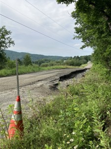
To obtain up-to-date information on back roads, people have resorted to posting questions to their personal social networks, or to other private Facebook groups such as VT Roads. But particularly for towns not providing written updates online, the first warning for drivers of closures or hazards might be a sign scrawled in marker or sparingly placed orange cones.
For emergency services providers during the height of the storm damage earlier this week, that created too much uncertainty.
In southern Vermont, Rescue Inc. staff spoke directly to road crews and did their own reconnaissance, said operations chief Drew Hazelton.
Rescue serves 14 towns that range from the Massachusetts border north to hard-hit Ludlow and Londonderry, and his drivers and emergency personnel needed to know whether, even if a road was closed to through traffic, a utility vehicle or truck could get through if needed.
Rescue Inc. keeps an up-to-date map that it uses internally and shares with emergency partners, Hazelton said. The organization does not make the map public, but does share information about road closures and openings with town officials.
Given what other pressing matters that town officials are managing, Hazelton said he would not be surprised if they have not been able to make that information more broadly available online.
“This work is being done largely by volunteers. There is not a lot of capacity in these towns to do that kind of constant updating,” he said. “It’s a lot, especially as things change.”
Road crews working doggedly over the past 24 hours have made huge strides in opening roads throughout the region, he added. Like others, Hazelton is now nervously watching the weather forecast.
“We’re crossing our fingers that the next storm doesn’t undo all the work they just did,” he said.
At Hardwick Rescue, the emergency response squad made similar calls seeking updates on Tuesday from neighboring emergency service organizations, town road crews and local police, and they spent time driving around to assess different access routes, said full-time EMT Buffy Casto.
To keep everything straight, her colleague Tyler Molleur, a volunteer, created a Google Map to plot what they knew about road closures.
“It got going when we were trying to just assess who in our service area we could get to and who we couldn’t, basically figuring out how to get to hospitals,” Casto said.
On Wednesday, they decided to make the map public. It has been widely shared as the most comprehensive resource for Hardwick and neighboring towns. It’s not fully in real time, Casto warned, but they are posting the updates as soon as they can.
“We’re quite proud of it,” she said.