

In a wacky winter season that has ranged from minus-50 wind chills to the springlike 50s, winter will make a comeback late Wednesday. Vermonters may even wake up to a pile of snow on their doorstep Thursday morning.
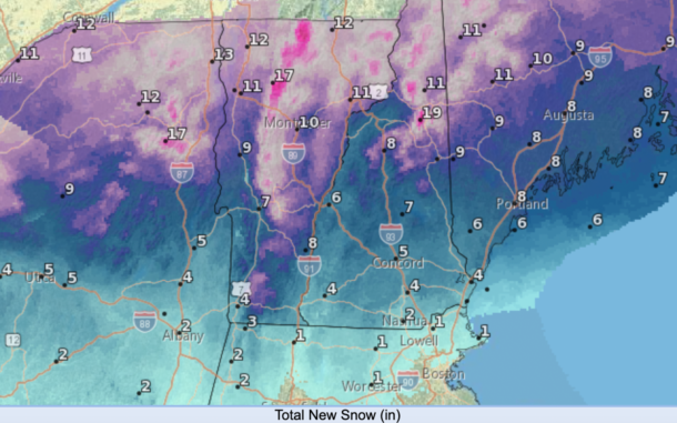
Northern counties can expect 8 to 11 inches of snow, starting Wednesday night and continuing through Thursday morning, according to Jessica Storm, a meteorologist at the Burlington office of the National Weather Service.
Southern counties in Vermont can expect 3 to 6 inches of snow, but it could be topped with a layer of sleet and freezing rain that could make driving and walking treacherous.
Storm, the aptly named meteorologist, recommends that drivers take extra caution late Wednesday night and early Thursday morning, give themselves extra time to arrive at a destination, and take it easy on the roads.
People headed home Wednesday should beat the storm if they leave by about 5 p.m., she said, but the ride could get hairy after 7 p.m., and visibility is expected to get progressively worse.
After the initial snowfall, there may be a break in precipitation on Thursday, but “we don’t want people to entirely let their guard down,” Storm said, “There’s kind of a second wave … coming Thursday night, but it should be less hazardous with lower snow amount, less of that wintry mix.”
Many public schools in southern Vermont are on winter break this week, but some schools in the northern counties start their vacation next week. Parents are advised to check for school cancellation notices, delays and possible changes in bus services.
The Burlington office of the National Weather Service does warn that storms can move more quickly than initially anticipated, and drivers should check for the latest information before setting out on the road.
Once the snowfall starts to pick up, Storm predicts it could drop at a 1-inch-per-hour rate, or higher, overnight on Wednesday.
Whatever happens, the Vermont Agency of Transportation says it will be prepared.
The agency plans to be “hitting the storm early with all of (its) 250 trucks as the storm dictates,” said Todd Law, deputy director in the agency’s district maintenance and fleet division.
Many of the state’s snowplow drivers expect to get a break “between 9 p.m. to 10 p.m. as long as conditions warrant until about 3 to 4 a.m. to get out for AM commute time on all routes,” he said via text message. “That will allow us to send some staff home overnight as our Snow and Ice Control plan depicts.”
Amy Tatko, director of communications and public outreach for the Vermont Agency of Transportation, said in a text message that drivers should “stay off the roads if possible during a storm, leave extra time to arrive at your destination, leave extra space between your vehicle and other vehicles, and don’t crowd the plow.”
The National Weather Service has more information on how to stay safe during and prepare for winter storms. Weather forecasts can change rapidly, so meteorologists advise people to check with their local weather stations, the National Weather Service forecasts and the weather app of their choice to keep track of what’s happening.